
Multispectral Crop Analysis with DJI Mavic 3 (Multispectral) + Pix4Dfields
Turn crop health into clear, actionable maps. NC Drone Co captures high-resolution multispectral imagery using mapped flight patterns and low ground sampling distances, then processes everything in Pix4Dfields to deliver precise indices, variability maps, and prescription-ready insights. We’ve logged hundreds of hours over row crops, orchards, and pastures across the Southeast.
How it works
We design mapped flight patterns for consistent frontlap/sidelap across the field. When beneficial, we add a cross-grid (crosshatch) pass to stabilize indices and improve canopy modeling over complex canopies.
- Altitude & overlaps tuned for low ground sampling distance (GSD)
- Time-of-day windows to minimize shadowing and BRDF effects
- Wind and sun angle considered for uniform radiometry
DJI Mavic 3 (Multispectral) collects synchronized bands for vegetative indices. Our pilots maintain constant speed, altitude, and line spacing for even coverage across the block.
- Consistent, low-GSD imagery for fine canopy variation
- Oblique/edge buffers to reduce boundary artifacts
- Optional ground targets & field notes (problem areas, pressures)
Imagery is processed in Pix4Dfields for rapid, field-scale results—no internet dependency. We verify seamlines and histogram balance before index generation.
- Orthomosaic, surface models, and index layers (NDVI, NDRE, GNDVI, VARI)
- Zonal analysis & management zones tailored to your operation
- Export georeferenced rasters, shapefiles, PDFs, and KMZ
We convert raw indices into prescriptions and practical actions—stress detection, vigor variability, stand gaps, and targeted scouting.
- Print-ready PDF maps with legends & scale bars
- Prescription & zone files for agronomy platforms
- Side-by-side before/after or multi-date comparison
Flight patterns, GSD & data quality
Mapped patterns: standard grid with tuned overlaps; optional crosshatch for heterogeneous canopies and late-season crops.
Low GSD: we plan altitudes and speeds to achieve fine ground resolution appropriate to crop stage and row spacing, supporting confident zone delineation and stand assessments.
Consistency: repeatable flight profiles enable reliable season-over-season comparisons and intervention tracking.
Quality controls:
- Overlap/coverage checks and seamline review
- Histogram and index sanity checks across blocks
- Edge buffering to reduce boundary effects
- Clear documentation of conditions (sun, wind, growth stage)
Deliverables you can use right away
You’ll receive digital files and visuals ready for agronomy workflows, VRA tools, and field meetings.
*Formats coordinated with your agronomist or platform.
Common use cases
- Stress & variability detection (moisture, fertility, disease, pest pressure)
- Stand counts & gap identification (stage-appropriate)
- Variable-rate trials, side-by-side comparisons, and product response
- Irrigation uniformity checks and drainage issues
- Pre-harvest prioritization and logistics planning
FAQs
What aircraft do you use?
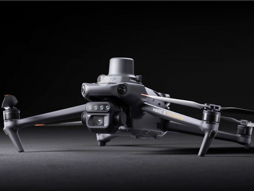
We deploy the DJI Mavic 3 Multispectral platform for synchronized spectral capture over row crops, orchards, and pastures. For specialty tasks, we can complement with additional UAS as needed.
How “fine” is the mapping?
We tune altitude, speed, and overlaps to achieve low GSD appropriate to crop and stage. This supports confident zone creation and detection of subtle canopy changes.
What software do you use?
Pix4Dfields for field-scale processing, index generation, zone mapping, and exports (GeoTIFF, SHP/GeoJSON, PDF, KMZ). We coordinate formats with your agronomist or equipment provider.
Do you provide prescriptions?
Yes. We can export management zones and prescription-ready files aligned with your tools. We’ll confirm formats and rate tables with your agronomy team.
Compliance & safety
All operations are conducted under FAA Part 107 with airspace and weather reviews, mission risk assessments, and property permissions documented prior to flight.
Ready to map your fields?
Tell us the crop, acreage, and timing window and we’ll recommend a flight + analysis plan.
Multispectral Crop Analysis Pricing
Pricing reflects standard operations across North Carolina and the Southeast using the DJI Mavic 3 Multispectral platform and Pix4Dfields processing. Each mission is customized to crop type, acreage, and desired outputs.
Base Field Mapping
$250 per field*
Includes flight, data capture, and basic NDVI map
Advanced Analysis
$350 – $450 per field
Pix4Dfields orthomosaic, NDVI/NDRE indices, and management zones
Prescription Packages
$500 – $750 per field
Zonal prescriptions, multi-date comparisons, and agronomist-ready exports
*Travel or acreage-based adjustments may apply. Volume pricing available for multi-field contracts.

Specifications:
DJI Mavic 3 Multispectral
20MP 4/3 CMOS RGB camera
Four 5MP multispectral cameras
Sunlight sensor
RTK module for centimeter-level positioning
43-minute max flight time
200-hectare coverage in one flight
O3 transmission up to 15km
Contact us.
Contact@ncdroneco.com