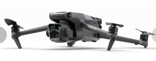
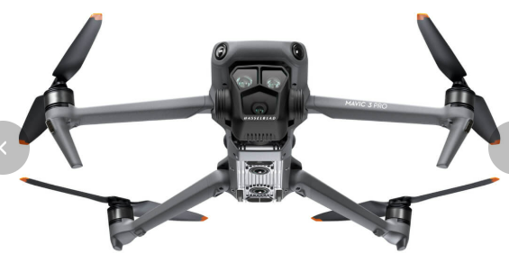
The DJI Mavic 3 Pro is a high-performance drone designed for professional-level photography, videography, and aerial applications. It’s packed with advanced features, including a triple-camera system, long flight time, and high-end sensors, making it a versatile tool for various use cases, including mapping and commercial work. Here’s a detailed breakdown of its specifications, suitability for mapping, pros and cons, and its use in commercial applications.
Specifications of the DJI Mavic 3 Pro
Triple-Camera System:
Main Camera: 4/3 CMOS Hasselblad camera (20 MP resolution, adjustable aperture f/2.8–f/11, 12.8 stops of dynamic range).
Medium Tele Camera: 1/1.3-inch CMOS (48 MP resolution, 3x zoom, f/2.8 aperture).
Telephoto Camera: 1/2-inch CMOS (12 MP resolution, 7x optical zoom, f/3.4 aperture).
Video Capabilities:
Up to 5.1K resolution at 50 fps or 4K at 120 fps.
D-Log M and 10-bit color profile for professional-grade editing.
Flight Performance:
Max Flight Time: ~43 minutes per battery in ideal conditions.
Range: Up to 15 km (9.3 miles) with O3+ transmission system.
Wind Resistance: Up to 12 m/s (~26.8 mph).
Mapping and Surveying Features:
RTK Module (optional): Enables high-precision mapping with centimeter-level accuracy.
Waypoint Missions: Allows automated flights for consistent and repeatable mapping.
Obstacle Avoidance:
360-degree omnidirectional obstacle sensing via multiple vision sensors.
Advanced Pilot Assistance System (APAS) 5.0 for smoother navigation.
App Support:
Compatible with DJI Fly and third-party apps like DroneDeploy, Pix4D, or ArcGIS Drone2Map for mapping purposes.
Storage:
8 GB internal storage, expandable via microSD card.
Can the DJI Mavic 3 Pro Be Used for Mapping?
Yes, the Mavic 3 Pro can be used for basic to intermediate mapping tasks. However, its suitability depends on the requirements of the project:
Aerial Photography-Based Mapping: Its high-resolution main camera can capture detailed images for 2D orthomosaics and 3D models.
RTK Module: Adding the RTK module significantly improves accuracy, making it more suitable for precise mapping, such as in surveying and construction.
Third-Party Software: Platforms like DroneDeploy or Pix4D enhance its mapping capabilities, enabling flight planning, data capture, and processing.
Limitations: While great for general mapping, the lack of a dedicated mapping camera (like multispectral or LiDAR) limits its use in highly specialized mapping (e.g., agriculture or vegetation analysis).
Can the Mavic 3 Pro Be Used for Commercial Purposes?
Absolutely. The Mavic 3 Pro is built for professional and commercial applications:
FAA Part 107 Compliance: To use the drone commercially in the U.S., operators must have an FAA Part 107 Remote Pilot Certificate.
Applications:
Real estate photography and videography.
Inspections (e.g., roof, infrastructure, utilities).
Basic mapping and surveying.
Film and media production.
Environmental monitoring and land management.
Advanced Features for Commercial Use:
Long flight time and reliable transmission system allow extended operations.
Triple-camera versatility meets the needs of different industries.
Pros of the DJI Mavic 3 Pro
Exceptional Camera System: The triple-camera setup provides flexibility for various tasks, including mapping, inspections, and cinematic work.
Long Flight Time: Up to 43 minutes per charge extends productivity.
Compact and Portable: Foldable design makes it easy to transport.
RTK Capability: With the optional RTK module, it can achieve high-accuracy mapping.
Obstacle Avoidance: Enhanced safety and ease of use with omnidirectional obstacle sensing.
Third-Party App Compatibility: Works with professional mapping and analysis software.
High Stability: Exceptional performance in windy conditions and high altitudes.
Cons of the DJI Mavic 3 Pro
Cost: High initial investment, especially with additional accessories like the RTK module and extra batteries.
Not Specialized for Advanced Mapping: While capable of general mapping, it lacks multispectral or LiDAR capabilities for advanced mapping tasks.
Limited Payload Options: Cannot carry heavier or specialized sensors.
Subscription Dependency: Some advanced mapping functionalities may require third-party software subscriptions.
Regulatory Considerations: Commercial operators must adhere to FAA Part 107 regulations and local airspace rules.
Conclusion
The DJI Mavic 3 Pro is an excellent drone for both mapping and commercial purposes, especially for professionals who need a versatile, high-quality aerial platform. It is particularly strong in photogrammetry-based mapping, inspections, and multimedia production. However, for specialized mapping applications (e.g., agricultural NDVI analysis or LiDAR surveying), other drones with specific sensors may be more appropriate.